

Heading North … Just Do It
We are now heading north toward the archipelago and surrounding cruising area know as the Broughtons. Generally this area is considered to encompass everything northwest of Campbell River and Desolation Sound and southeast of the northern tip of Vancouver Island, even though the Broughtons proper is just the collection of small islands northeast across the Queen Charlotte Strait from Port McNeill.
The area is made up of islands both small and big, and long inlets and channels winding in and around the mainland. It’s sparsely populated with few places that house a full-time population. But it’s also home to some stunning scenery, fantastic fishing, and the most fascinating collection of marinas and resorts you will find anywhere.

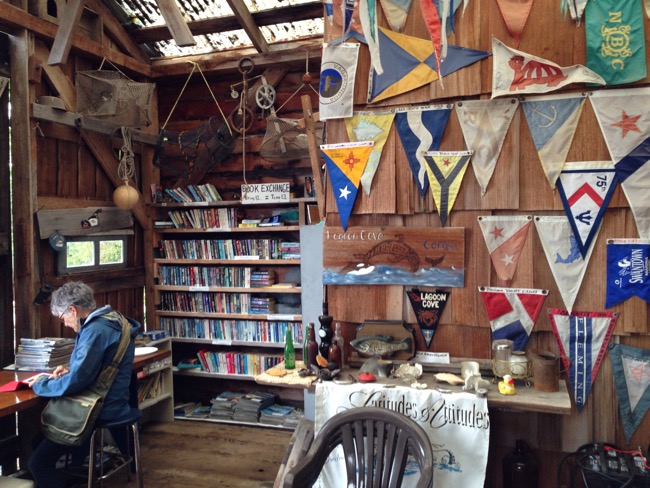
Lagoon Cove, West Cracroft
Now when I say resort, you might picture huge spa-like edifices with all the amenities, or quaint “rustic” hotels tucked away in a pleasant cove with all the services. But while there may be one or two resorts vaguely similar to the latter, dedicated to kayakers and fisherman, I’ve seen no sign of the former. No, a resort in the Broughtons is generally one small group of buildings on shore and a collection of docks and floating buildings. In some, all the amenities are on the water and there isn’t anything on land to speak of. But they are all tucked away in beautiful picturesque coves.
And the communities are great. They host happy hours and potlucks, have pig roasts and shrimp feasts, or are simply known for their hospitality and free pancakes. The boaters tend to be veterans who come again and again, and the collegial atmosphere is a lot of fun.
It sounds, and is, idyllic. But many, many of the boaters who habituate the southern Gulf Islands will never venture north.
A Few Challenges
It’s a long way, and intimidating on paper. There are a lot of obstacles to making the trip, and I think many people believe they are insurmountable, or at least too difficult to justify the reward. But that’s just not true…at least in my opinion.
Now to be fair, we first ventured up to the Broughtons in a flotilla organized by Cooper Boating out of Vancouver. And their two-week itinerary started out of Powell River (Westview), so it cut some of the distance out of the process. For ourselves, we left from Vancouver and took an extra week to get used to our charter boat before we met up with the flotilla. Nonetheless, I am a convert and think all the rushing was absolutely worthwhile.

A String of Rapids
The second, and arguably larger, deterrent to heading north is that it is impossible to get into the Broughtons or anywhere north of Desolation Sound without hitting a major set of rapids or a narrow channel with a major current.
I have read countless posts and sidebars and guidebooks explaining how best to negotiate these watery roadblocks, but frankly I think they have the opposite effect. All the ‘helpful’ advice just a serves to make the process sound daunting. I have made passage through the area five times so far and am starting to wonder if there’s not a conspiracy to keep the Broughtons to ourselves.
What You Need to Understand Is…
The incoming tides in the PNW sweep around Vancouver Island flowing south from the Queen Charlotte Strait in the north and flowing north up from the Strait of Juan de Fuca. They meet basically at Desolation Sound. But because south of the Sound is fairly open you only see strong currents in the few passes in and around the Gulf Islands.
North of the Sound is a maze of channels and passages and all of them have narrow points here and there that force the water to speed up.
Now I admit to not having an tremendous amount of experience in general when it comes to boating, but it’s a curve and I am working my way up it. My opinion is that if you are boating in the PNW, and especially the Southern Gulf Islands, then you need to learn to deal with currents. And if you’ve learned to negotiate Dodd Narrows or Porlier Pass, then you have all the experience and knowledge you need to keep going north.
For those of you who don’t already understand, let me break it down. The reason that the currents and rapids occur is that the tides force billions of litres of water back and forth four times a day. Roughly every six hours the tides shift from ebb (going out) to flood (coming in). In a nice open body of water like the Strait of Georgia, the effect of this shifting can range anywhere from negligible to creating three or four knots of current. When all this water is forced into narrow choke points in narrow passages, the current can exceed eight to ten knots. Given that the top speed of my boat is seven knots, you can see that I wouldn’t have any hope of going though a pass against that kind of current. And the narrower the passage, the more likely the water is to boil up into actual rapids. Skookumchuk Rapids near Sechelt are the kind of rapids that are like candy to whitewater kayakers. All caused by the tide.
Still, if you transit any pass at slack tide, the point at which the tide is neither ebbing or flooding, the current virtually disappears, even at Skookumchuk. Slack can last from a few minutes to half an hour, and you generally have some time on either side when the current is starting to build, at which point current is not much of an issue — especially if you are transiting the passage in the same direction as the new tide; then it just gives an extra push.
All of this is something you need to learn to boat safely in the Gulf Islands and that knowledge, ans the nature of the rapids, doesn’t change just because you are going north.
Make Your Choice
Each of the three major routes you can take has its own challenges. I have yet to transit through Seymour Narrows near Campbell River, but it has its own idiosyncrasies that the above-mentioned writers have produced tons of info about. It is the only route that has just one portion of fast water to worry about — Seymour Narrows itself — but you also have to contend with all the big ships and the longest passage through Johnstone Strait, which can get a bit bumpy at times.
Going north, the middle route, up along the east side of Quadra Island takes you through Surge Narrows rapids and then the Upper Rapids about 6nm later. But if your boat is too slow or the timing just doesn’t work, then the Octopus Islands are right in between and are a spectacular anchorage every boater should visit at least once. So it’s win-win.
After you transit Upper Rapids you follow Okisollo Channel until it dumps you out into Johnstone Strait.
The third way, and seemingly most popular, is up through the Yucultas. This route takes you north of Desolation Sound and past Cortes Island. You proceed up Calm Channel until you hit the Yucultas, which are the first of three sets of rapids: the Yucultas, Gillard, and Dent Rapids. Between the Yucultas and Gillard is Big Bay and the Stuart Island Community Marina, which is well worth a stop if you don’t want to run all three. A nice little store and a clean shower, but no power on the docks.

To transit all three it is best to go with the current, but I’ve seen sailboats go against it, too. The decision comes down to preference and confidence. If you are ok running Dodd Narrows an hour early or late, then these three will be fine at slack. Anyway there is plenty of advice online about timing. What I want to add is that, based on what we have been through, I have wondered what the big deal is. I mean to come back one day in a powerful speedboat and see what the rapids are truly like when they are running. But with Never for Ever I am content with the ripples and eddies I have experienced.

Approaching Dent Rapids at slack.
A bit further up you will run into the Green Point Rapids, Blind Channel Rapids, and Whirlpool Rapids. While they all have significant currents they really aren’t a threat either, at least not in small tides. This trip we ran Whirlpool with a predicted current of 3.5 knots and hit a top speed of 10 knots as the current pushed us along. Another sailboat that was with us later told us he’s never had trouble there.
Big Bad Johnstone Strait
The last big impediment to people frequenting the Broughtons is Johnstone Strait. It is impossible to get into the Broughtons without spending at least some time in the Strait. And it can get bad — or so I’ve heard. We have had extraordinary luck and have either motored on glassy waters or sailed in 10 to 15 knots. So while there are bad days, just as there are in the Strait of Georgia, watching the weather and good timing can solve that issue easily. And depending on the route you take, you can shorten the amount of time you spend there.

Johnstone Strait on a good day.
So What I am Saying Is…
I am not saying that making your way to the Broughtons is a float on a pond. There are difficulties and some things to be wary of. What I am saying is that if you regularly boat in the Salish Sea, nothing in the trek north should surprise you or overwhelm you. It’s probably best if you have more than two weeks to do it, but even then, why not? (I joined a trip around Vancouver Island this spring that we did in two weeks. It was a lot of miles but thoroughly worthwhile.) The Broughtons’ unique combination of stunning scenery and friendly communities is worth the bit of trouble that getting there entails.
As Nike is wont to say, just do it.