

The Pilgrimage to Princess Louisa Inlet

From the very first moment I ever considered boating in the PNW, a journey to Princess Louisa Inlet has been held up as the quintessential, must-do voyage. Every guidebook, every charter company’s trip planner, every boater we met, all talked about the beauty and majesty of that mystical destination. But frankly, after a season or two of visiting some of the “popular” destinations and then getting the chance to explore some destinations off the beaten path, I had almost decided to give Princess Louisa a pass. At the very most, my latest plan was to charter a powerboat and get in and get out so I wouldn’t have to deal with the crowds that are generally associated with the “must do’s” but still be able to say I’d seen it. And yes, I realize I was being a bit cynical.
But as we pulled out of Smuggler Cove, we talked it over and decided that the week before the Victoria Day long weekend was probably our best shot at a quiet visit and the high-water slack at Malibu Rapids was currently somewhere between 5 and 6 p.m. so we could still have a reasonable start for the five- to six-hour trip up the various reaches to Malibu Rapids at the mouth of Princess Louisa. So we decided, what the hell, let’s give Louisa a chance.
We departed Smuggler Cove in a light fog and motored up Agamemnon Channel doing a bit of radar review, and a couple of hours later arrived at Backeddy Resort and Marina outside Egmont. I had given the Bathgate General Store, Resort and Marina located right in Egmont a call as we wanted to pick up some fresh produce there instead of stopping at Madiera Park in Pender Harbour. But the lady on the phone informed me it was too shallow for sailboats although there was some space at the government dock. As we still wanted to top up the water and batteries we opted for Backeddy. Backeddy has strong currents and a lot of bouncing and rolling when the powerboats and tugs go by, but it settles down at night although the $60 tab I could have done without. Safely tied up we lowered the outboard onto the dinghy and took off for Egmont. But our trip was to no avail; the only fresh produce available was potatoes and yams, the former of which we had and the latter not in any way a part of my dietary preferences.
The next morning we cleaned up a bit and cast off around 10 a.m.; at an average of 5.5 knots, it would get us there at around 4 p.m. for the 5:05 slack. I went to the trouble of setting up a route on the chartplotter so we could keep an eye on the ETAs between waypoints as we progressed. This turned out to be some brilliant foresight because at 2400 rpm we started off doing 6.5 knots, well above my estimated average. As the long journey progressed I kept dropping the revs until, on the last legs, we were putting along at a mere 1900 rpm and still maintaining a 5.5 knot SOG (speed over ground).
The journey up the various reaches (Prince of Wales, Princess Royal Reach and Queens Reach) is a different kind of trip than we’ve taken before. There was zero traffic the whole way except for one tug coming out of a logging camp. The legs are long and straight with great visibility and forty-five minutes to an hour between turns. And we saw very little detritus and no logs whatsoever in the water. This meant we could set up the autopilot on each leg to head to the next waypoint and then relax in the beautiful weather and scenery with a slightly less vigilant watch; the alarm (not that we relied on it) would make sure we made our turn. It was a lot like I imagine an offshore watch would be like.
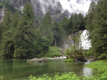
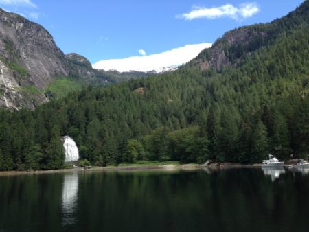
Given the the good speed we were making we spent the last 4 or 5 nautical miles idling along the tiny beaches in the lower part of Queens Reach, and then let out the sails to almost drift in the 5- or 6-knot winds while we waited for the turn. I could see on the AIS that the small cruise ship Safari Queen was waiting on the other side to make the transit. She made a securité call at around 20 minutes to 5 announcing her intentions and then came through. We waited until 10 minutes to 5 before starting our run, making the actual transit about 10 minutes before full slack. We had about a knot of current pushing us, but it was uneventful in the extreme. Once on the other side the mountains seem to close in, and the 5-mile trip to the end of the inlet is breathtaking, surrounded by high cliffs and, at this time of year, dozens and dozens of waterfalls.
At the end of the inlet, four boats were already tied up to the docks, and one was anchored at the base of the falls. Two other followed us in, but that still left plenty of room on the spacious docks. The use of the docks (and five mooring balls behind Macdonald Island) is free but a suggested donation is recommended.
When we visited Newfoundland’s Gros Morne National Park many years ago we had taken a tourist boat trip up Western Brook Pond, the Newfoundlanders’ understated name for a massive fjord. The trip through Princess Louisa was both slightly less, and slightly more, impressive and awe-inspiring. But unlike Gros Morne, the kicker at Princess Louisa is rounding a final corner and seeing the long narrow valley that wraps around Chatterbox Falls, funnelling the water down over 1500 feet to the base where the docks are. This view disappears once you get in close, so be sure to take it slow and savour the multiple cascades from mountain top to sea level as you approach.
Besides the large UnCruise boat that had left as we arrived, another tourboat — a high-speed zodiac out of Egmont — made several trips in with its visitors bundled up in survival suits. The guide said it was about an hour and a half trip out for them including stops. Each trip he would pause so they could take pictures at the base of the falls and then allow them 30 minutes to explore before bundling them back aboard and zooming off for home. Several other boats came and went during our visit, including a lovely old wooden powerboat built in the 1920s, with a maximum of eight boats on the docks at any given time. I imagine this is very quiet compared to July or August — they have a suggested 72 hour maximum to ensure everyone gets a chance. A few of the other boats stayed for more than two evenings, but one boat arrived on the evening slack and left the next day by noon — that seems like such a waste an experience.
 The first thing that hit us after we had Never for Ever secured to the dock was the taste of the air. The base of the falls is much bigger than we expected, and the moist, cool air produced by the crashing water was loaded with smells and tastes that can most aptly be described as clean and fresh. This sensation occurred again and again during our stay as we would round a corner on a path or poke our heads up from below. It was as if every scent produced by the verdant growth was buoyed up by the dense air and delivered gently to our nostrils. Throughout our stay both Leslie and I would remark on it each time we strayed from our boat.
The second thing we noticed is the sound. The background roar of the falls never leaves. Your voices are a bit louder while you are here, you don’t hear the powerboat running his engines, and you fall asleep to the sound of a “fan” you just can’t shut off. For all its volume, it’s much subtler than the scent of the place. The air hits your senses in waves, coming and going, but the sound is always there, in the background until you notice it at the oddest moments.
When we walked up to the base of the Chatterbox Falls I — having for some strange reason changed from synthetics to cottons — got appropriately drenched by the ever-present mist. Thousands of litres of water are pounding down the mountain side, throwing water in every direction. Between the shadows and the immense amount of water and spray in the air, it’s difficult to get a picture that appropriately captures the grandeur of Chatterbox Falls, but I had fun trying. Later, when the wind came up and blew the mist back against the falls, I did manage to get a few clearer images of the water cascading down the rocks that might, somehow, capture the essence of the experience.
Low tide is also a very interesting time here. The sandbars created by the many outflows of water extend quite a distance beyond the base of the falls and makes for great sand cats and interesting exploring. Swimming here is not advised because of the presence of lions mane jelly fish (and, I imagine, the glacier cold water). Along the docks there were hundreds of jellyfish swimming in the water ranging from a few inches to more than a foot across. We also found many unfortunate ones lying on the rock where they were trapped by the receding tides. We wonder if they can survive their time out of the water, but the dead ones we saw floating later as the tide came back in seems to indicate they can’t. The shore is littered with clam shells, and a myriad collection of basalt and granite stones with a full complement of sizes from the tiniest specks to bowling-ball-size rocks. The action of the outflow tends to group them according to their size so as you explore you find these collections of similar diameter sand, gravel, stones and rocks.

At one point the wind came up in late afternoon and the boat at anchor began to swing. Normally the current from the falls is enough to keep a boat bow towards shore. Waggoners recommends a stern anchor in case of such winds but they obviously didn’t have one. After an hour or two of anchor watch they joined us on the dock, noting that after the second time their anchor dragged they had lost confidence that it was going to hold. And, in the way of such things, the wind died a few minutes after they were safely tied up. Other than that brief spell, the weather remained very calm, albeit cloudy and rainy on the secondhand third day.
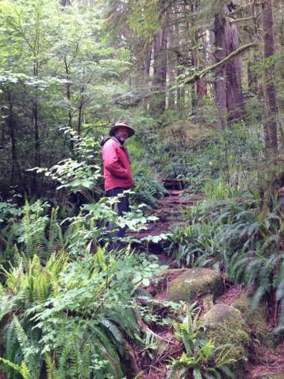
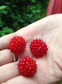
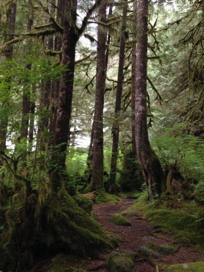
There are few trails here, and some picnic tables and fire pits, with one larger shelter and fire pit built by the Princess Louisa International Society. But other than at low tide, exploring and hiking is pretty much limited to one “arduous” trail with a 500-meter elevation gain up to an old trapper’s cabin. On our short walks we did find lovely displays of Nootka roses that added their scent to the air, Queen Anne’s Lace in bloom, plenty of red and orange salmonberries to feed your inner bear, and lots of tiny wildflowers, including some native bleeding hearts (Dicentra formosa) and silverweed (Potentilla anseria).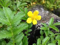 Here and there in the mostly coniferous forest, broad maple trees are covered with moss and the word verdant realizes its true meaning in this moist, healthy ecosystem with lush undergrowth and soaring deciduous and coniferous trees that create a canopy coloured in myriad shades of green.
A magnificent place. I can see how it might lose some of its wonder in high season, and the circumstances created by distance and geography certainly lend themselves to the tendency to make it one of those spots where you arrive, take in the splendour and move on. But, as in so much of the beautiful coast of B.C., if you come at a quiet time and take the time to just sit and appreciate, you will find much to keep mind and soul fed for days. We certainly did.
After I wrote this post, but before I posted it, Andy Cross from Yahtzee posted a remarkably similar post. They were entering Malibu as we were leaving. Well worth a read.